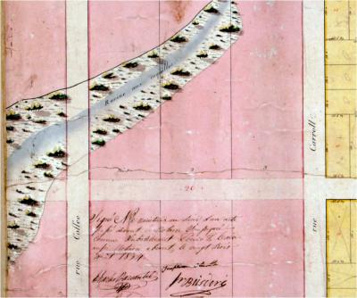
Ravine Aux Coquilles
Ravine aux Coquilles (shell ravine). This small natural bayou is identified in the earliest maps of the area, long before the development of Mandeville. The Bayou figures prominently in the 1834 map that laid out the town by Louisiana Surveyor General and Marigny friend, Louis Bringier.
Bernard de Marigny created a list of covenants to direct the establishment of the town, which were attached to each real estate transaction. In an English translation, one covenant as it relates to the protection of the waterways, is laid out as follows:
" That Little Bayou Castine (outlet located in 1600 block of Lakeshore Drive) which serves to drain, will not be stopped in its course as it is also with the Shell Ravine in the width of at least 25 feet taken from their centers."
Drainage and flooding, two opposing forces, continue to be major issues in this lake town, as Marigny understood almost 200 years before.


